SAR Wallaway: Difference between revisions
No edit summary |
mNo edit summary |
||
| (30 intermediate revisions by the same user not shown) | |||
| Line 1: | Line 1: | ||
<table> <!-- BEGIN TOP TABLE --> | |||
<tr valign="top"> | |||
<td width=750> | |||
<table width=750> <!-- BEGIN TABBED link list with Home page active--> | |||
<tr valign="top"> | |||
<td align="center">[[Image:line740.png|link=]]</td> | |||
</tr> | |||
<tr valign="top"> | |||
<td align="center">[[image:Tab_HM_White.png|link=]] [[image:Tab_IN_Grey.png|link=SAR_Wallaway_Industry]] [[image:Tab_TM_Grey.png|link=SAR_Wallaway_TrackMarks]] [[image:Tab_SW_Grey.png|link=SAR_Wallaway_Switches]] [[image:Tab_Blank_Grey.png|link=]]</td> | |||
</tr> | |||
<tr valign="top"> | |||
<td align="center">[[Image:line740.png|link=]]</td> | |||
</tr> | |||
</table> <!-- END TABBED link list --> | |||
<table bgcolor="lightgrey" bordercolor="lightgrey" width=750> <!-- BEGIN Location link table with LINE and STATION NAMES --> | |||
<tr valign="middle"> | <tr valign="middle"> | ||
<td width=220 align="right">[[Image:SAR_Peterborough-Quorn_Line.png|link=SAR Peterborough-Quorn | <td width=220 align="right">[[Image:SAR_Peterborough-Quorn_Line.png|link=SAR Peterborough-Quorn|alt=Peterborough-Quorn|Show Peterborough-Quorn]]</td> | ||
<td width=110 align="center">[[Image:Next Left.png|link=|alt=]]<br>[[Image:SAR_Orroroo_Name.png|link=SAR Orroroo|alt=Orroroo|Next Up Location]]</td> | <td width=110 align="center">[[Image:Next Left.png|link=|alt=]]<br>[[Image:SAR_Orroroo_Name.png|link=SAR Orroroo|alt=Orroroo|Next Up Location]]</td> | ||
<td width=90 align="center">[[Image:Location Index.png|link=SAR Index|alt=Location Index|Location Index]]</td> | <td width=90 align="center">[[Image:Location Index.png|link=SAR Index|alt=Location Index|Location Index]]<br>[[image:Scenario Index.png|link=SAR Peterborough Base Session|alt=Scenarios]]</td> | ||
<td width=110 align="center">[[Image:Next Right.png|link=|alt=]]<br>[[Image:SAR_Halls_Well_Name.png|link=SAR Halls Well|alt=Halls Well|Next Down Location]]</td> | <td width=110 align="center">[[Image:Next Right.png|link=|alt=]]<br>[[Image:SAR_Halls_Well_Name.png|link=SAR Halls Well|alt=Halls Well|Next Down Location]]</td> | ||
<td width=220 align="left">[[Image:SAR_Peterborough-Quorn_Line.png|link=SAR Peterborough-Quorn | <td width=220 align="left">[[Image:SAR_Peterborough-Quorn_Line.png|link=SAR Peterborough-Quorn|alt=Peterborough-Quorn|Show Peterborough-Quorn]]</td> | ||
</tr> | </tr> | ||
</table> <!-- END Location link table with LINE and STATION NAMES --> | |||
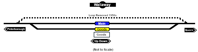
[[image:SAR_Wallaway.png|link=|alt=Wallaway map]] | |||
<table bgcolor="lightgrey" bordercolor="lightgrey" width=750> <!-- BEGIN Location details table --> | |||
<tr valign="top"> | |||
<td><span style="font-weight: 700; background-color: black; color: white;"> Commodities: </span> | |||
<table width=300> <!-- BEGIN Commodities table (5 items) --> | |||
<tr valign="top"> | <tr valign="top"> | ||
<td | |||
[[Image:Goods_Icon.png|link=|alt=Goods]]</td> | <td align="center" width=50>[[Image:Goods_Icon.png|link=|alt=Goods]]<br><span style="font-size: 10px; font-weight: 700;">Goods</span><br>[[image:Goods_Label.png|link=]]</td> | ||
<td | <td align="center" width=50> </td> <!-- holding space 2 --> | ||
<td align="center" width=50> </td> <!-- holding space 3 --> | |||
<td align="center" width=50> </td> <!-- holding space 4 --> | |||
<td align="center" width=50> </td> <!-- holding space 5 --> | |||
</tr> | </tr> | ||
</table> | </table> <!-- END Commodities Table --> | ||
<table | |||
<tr> | </td> | ||
<td | <td> | ||
<table width=175> <!-- BEGIN Loco table (3 items) --> | |||
<tr valign="top"> | |||
<td width=175> </td> <!-- holding space 1-3 for no Loco items - REMOVE black background and "Loco Serices" label --> | |||
</tr> | </tr> | ||
</table> <!-- END Loco table --> | |||
</td> | |||
<td> | |||
<table width=250> <!-- BEGIN Facilities table (4 items) --> | |||
<tr valign="top"> | <tr valign="top"> | ||
<td width=250> </td> <!-- holding space 1-4 for no Facility items - REMOVE "Facilities" label --> | |||
<td | |||
< | |||
</tr> | </tr> | ||
< | </table> <!-- END Facilities Table --> | ||
< | |||
</td> | |||
</tr> | </tr> | ||
< | </table> <!-- END Location details table --> | ||
< | |||
< | <table> <!-- BEGIN Information Table --> | ||
< | |||
< | <tr valign="top"> | ||
< | <td width=750> | ||
< | <span style="font-weight: 700;"><span style="color: white; background-color: black;"> Distance from Peterborough: </span> 46¼ kms, 28¾ miles</span><br> | ||
Unmanned location on the <span style="font-weight: 700; color: white; background-color: black;"> Peterborough-Quorn Line </span>.<br> | |||
A goods loop with a small goods shed was the only structure. A crossing loop was removed during the 1950s due to the reduction in traffic on the line.<br> | |||
Just south (on the '''Peterborough''' side) of '''Wallaway''' is a culvert that was the site of the only serious incident on the line - a head on collision between two trains in the early hours of Saturday 16th November 1901. The firemen on both locos were killed and the drivers injured.<br> | |||
The line from '''Peterborough''' to '''Eurelia''' was closed to normal traffic in 1988 and was fully closed in 2002. Most of the track was removed in 2008.<br> | |||
Today the culvert at the accident site and the track back to the yard have been preserved. A monument has been constructed at the site from materials retrieved from the goods shed when it was demolished. | |||
</td> | |||
</tr> | </tr> | ||
<tr valign=" | |||
<tr valign="top"> | |||
<td align="center">[[Image:line740.png|link=]]</td> | |||
<td align="center">[[Image: | |||
</tr> | </tr> | ||
</table> <!-- END Information Table --> | |||
</td> | |||
<td> | <td> | ||
[[ | [[Image:SAR_Peterborough-Quorn_Line.png|link=SAR_Peterborough-Quorn|alt=Peterborough-Quorn|Show Peterborough-Quorn]]<br> | ||
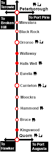
[[Image:SAR_Peterborough-Quorn Strip Map.png|link=|alt=Peterborough-Quorn Strip Map]]</td> | |||
</tr> | </tr> | ||
</table> | </table> <!-- END TOP TABLE --> | ||
Latest revision as of 07:12, 26 September 2022
|
 |