SAR Carrieton: Difference between revisions
expanded trackmark info |
mNo edit summary |
||
| (22 intermediate revisions by the same user not shown) | |||
| Line 1: | Line 1: | ||
<table> | <table> <!-- BEGIN TOP TABLE --> | ||
<tr valign="top"> | <tr valign="top"> | ||
<td width=750> | <td width=750> | ||
[[Image: | |||
< | <table width=750> <!-- BEGIN TABBED link list with Home page active--> | ||
<tr valign="top"> | |||
<td align="center">[[Image:line740.png|link=]]</td> | |||
</tr> | |||
<tr valign="top"> | |||
<td align="center">[[image:Tab_HM_White.png|link=]] [[image:Tab_IN_Grey.png|link=SAR_Carrieton_Industry]] [[image:Tab_TM_Grey.png|link=SAR_Carrieton_TrackMarks]] [[image:Tab_SW_Grey.png|link=SAR_Carrieton_Switches]] [[image:Tab_Blank_Grey.png|link=]]</td> | |||
</tr> | |||
<tr valign="top"> | <tr valign="top"> | ||
<td | <td align="center">[[Image:line740.png|link=]]</td> | ||
[[ | |||
</td> | |||
</tr> | </tr> | ||
</table> | </table> <!-- END TABBED link list --> | ||
<table bgcolor="lightgrey" bordercolor="lightgrey" width=750> <!-- BEGIN Location link table with LINE and STATION NAMES --> | |||
<tr valign="middle"> | <tr valign="middle"> | ||
<td width=220 align="right">[[Image:SAR_Peterborough-Quorn_Line.png|link=SAR Peterborough-Quorn | <td width=220 align="right">[[Image:SAR_Peterborough-Quorn_Line.png|link=SAR Peterborough-Quorn|alt=Peterborough-Quorn|Show Peterborough-Quorn]]</td> | ||
<td width=110 align="center">[[Image:Next Left.png|link=|alt=]]<br>[[Image:SAR_Eurelia_Name.png|link=SAR Eurelia|alt=Eurelia|Next Up Location]]</td> | <td width=110 align="center">[[Image:Next Left.png|link=|alt=]]<br>[[Image:SAR_Eurelia_Name.png|link=SAR Eurelia|alt=Eurelia|Next Up Location]]</td> | ||
<td width=90 align="center">[[Image:Location Index.png|link=SAR Index|alt=Location Index|Location Index]]</td> | <td width=90 align="center">[[Image:Location Index.png|link=SAR Index|alt=Location Index|Location Index]]<br>[[image:Scenario Index.png|link=SAR Peterborough Base Session|alt=Scenarios|Scenario Index]]</td> | ||
<td width=110 align="center">[[Image:Next Right.png|link=|alt=]]<br>[[Image:SAR_Moockra_Name.png|link=SAR Moockra|alt=Moockra|Next Down Location]]</td> | <td width=110 align="center">[[Image:Next Right.png|link=|alt=]]<br>[[Image:SAR_Moockra_Name.png|link=SAR Moockra||alt=Moockra|Next Down Location]]</td> | ||
<td width=220 align="left">[[Image:SAR_Peterborough-Quorn_Line.png|link=SAR Peterborough-Quorn | <td width=220 align="left">[[Image:SAR_Peterborough-Quorn_Line.png|link=SAR Peterborough-Quorn|alt=Peterborough-Quorn|Show Peterborough-Quorn]]</td> | ||
</tr> | </tr> | ||
</table> <!-- END Location link table with LINE and STATION NAMES --> | |||
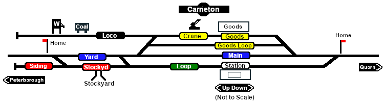
[[image:SAR_Carrieton.png|link=|alt=Carrieton map]] | |||
<table bgcolor="lightgrey" bordercolor="lightgrey" width=750> <!-- BEGIN Location details table --> | |||
<tr valign="top"> | <tr valign="top"> | ||
<td | <td><span style="font-weight: 700; background-color: black; color: white;"> Commodities: </span> | ||
<table> | |||
<table width=300> <!-- BEGIN Commodities table (5 items) --> | |||
<tr valign="top"> | <tr valign="top"> | ||
<td align="center">[[Image: | |||
<td align="center">[[Image:Goods_Icon.png|link=|alt=Goods]]<br><span style="font-size: 10px; font-weight: 700;">Goods</span></td> | <td align="center" width=50>[[Image:Passenger_Icon_off.png|link=|alt=Passengers]]<br><span style="font-size: 10px; font-weight: 700;">Passengers</span><br>[[image:Station_Label.png|link=]]</td> | ||
<td align="center">[[Image:Livestock_Icon.png|link=|alt=Livestock]]<br><span style="font-size: 10px; font-weight: 700;">Livestock</span></td> | <td align="center" width=50>[[Image:Goods_Icon.png|link=|alt=Goods]]<br><span style="font-size: 10px; font-weight: 700;">Goods</span><br>[[image:Goods_Label.png|link=]]</td> | ||
<td align="center" width=50>[[Image:Livestock_Icon.png|link=|alt=Livestock]]<br><span style="font-size: 10px; font-weight: 700;">Livestock</span><br>[[image:Stockyard_Label.png|link=]]</td> | |||
<td align="center" width=50> </td> <!-- holding space 4 --> | |||
<td align="center" width=50> </td> <!-- holding space 5 --> | |||
</tr> | </tr> | ||
</table></td> | </table> <!-- END Commodities Table --> | ||
<td style="background-color: black;"><span style="color: white; font-weight: 700;">Loco:</span> | |||
<table> | </td> | ||
<td style="background-color: black;"><span style="color: white; font-weight: 700;"> Loco Services: </span> | |||
<table width=175> <!-- BEGIN Loco table (3 items) --> | |||
<tr valign="top"> | <tr valign="top"> | ||
<td align="center">[[Image:Coal_Icon.png|link=|alt=Coal]]<br><span style="font-size: 10px; color: white; font-weight: 700;">Coal</span></td> | |||
<td align="center">[[Image:Water_Icon.png|link=|alt=Water]]<br><span style="font-size: 10px; color: white; font-weight: 700;">Water</span></td> | <td align="center" width=50>[[Image:Coal_Icon.png|link=|alt=Coal]]<br><span style="font-size: 10px; color: white; font-weight: 700;">Coal</span><br>[[image:Loco_Label.png|link=]]</td> | ||
<td align="center" width=50>[[Image:Water_Icon.png|link=|alt=Water]]<br><span style="font-size: 10px; color: white; font-weight: 700;">Water</span><br>[[image:Loco_Label.png|link=]]</td> | |||
<td align="center" width=50> </td> <!-- holding space 3 --> | |||
</tr> | </tr> | ||
</table></td> | </table> <!-- END Loco table --> | ||
<td | |||
<table> | </td> | ||
<td><span style="font-weight: 700;"><span style="background-color: black; color: white;"> Facilities: </span></span> | |||
<table width=250> <!-- BEGIN Facilities table (4 items) --> | |||
<tr valign="top"> | <tr valign="top"> | ||
<td align="center">[[Image:Loop_Icon.png|link=|alt=Loop]]<br><span style="font-size: 10px; font-weight: 700;">Loop</span></td> | |||
<td align="center" width=50>[[Image:Loop_Icon.png|link=|alt=Loop]]<br><span style="font-size: 10px; font-weight: 700;">Loop</span><br>[[image:Loop_Label.png|link=]]</td> | |||
<td align="center" width=50> </td> <!-- holding space 2 --> | |||
<td align="center" width=50> </td> <!-- holding space 3 --> | |||
<td align="center" width=50> </td> <!-- holding space 4 --> | |||
</tr> | </tr> | ||
</table></td> | </table> <!-- END Facilities Table --> | ||
</td> | |||
</tr> | </tr> | ||
</table> | </table> <!-- END Location details table --> | ||
<table | |||
<table> <!-- BEGIN Information Table --> | |||
<tr valign="top"> | <tr valign="top"> | ||
<td | <td width=750> | ||
<span style="font-weight: 700;"><span style="color: white; background-color: black;"> Distance from Peterborough: </span> 71½ kms, 44½ miles</span><br> | |||
Manned station on the <span style="font-weight: 700; color: white; background-color: black;"> Peterborough-Quorn Line </span> up to November 1930 when all staff were withdrawn.<br> | |||
Station, crossing and goods loops with a stockyard siding and loco servicing siding.<br> | |||
The township of '''Carrieton''' is 2 miles to the East of the station. The cottages built at both ends of the yard were to accommodate the line maintenance crews and their families.<br> | |||
Some of the station buildings on the line, such as here at '''Carrieton''', were built in a far "grander style" than was needed as it was hoped that the line would attract many settlers and industries to the region. This hope was never fulfilled. Passenger services ceased in 1969 when the '''Port Pirie''' to '''Broken Hill''' line was converted to standard gauge (4ft8½in - 1435mm).<br> | |||
The line from '''Eurelia''' to '''Quorn''' was closed in 1987 and most of the track was removed in 2008.<br> | |||
The station building at '''Carrieton''' is now a private residence. | |||
</td> | |||
</tr> | </tr> | ||
<tr valign="top"> | <tr valign="top"> | ||
<td | <td align="center">[[Image:line740.png|link=]]</td> | ||
</tr> | </tr> | ||
</table> <!-- END Information Table --> | |||
</ | |||
</td> | |||
<td> | <td> | ||
[[ | [[Image:SAR_Peterborough-Quorn_Line.png|link=SAR_Peterborough-Quorn|alt=Peterborough-Quorn|Show Peterborough-Quorn]]<br> | ||
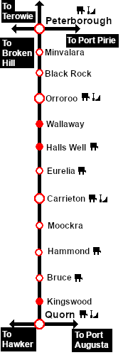
[[Image:SAR_Peterborough-Quorn Strip Map.png|link=|alt=Peterborough-Quorn Strip Map]]</td> | |||
</tr> | </tr> | ||
</table> | </table> <!-- END TOP TABLE --> | ||
Latest revision as of 00:51, 27 September 2022
|
 |