SAR Index: Difference between revisions
From TrainzOnline
Jump to navigationJump to search
m preparation for v2.0 release |
mNo edit summary |
||
| (20 intermediate revisions by the same user not shown) | |||
| Line 1: | Line 1: | ||
<!-- V1.0 --> | |||
<table width=1000> | |||
<tr valign="top"> | <tr valign="top"> | ||
<td align="center" width=800><span style="background-color: blue; color: white; font-weight: 700; font-size: 21px"> SAR Peterborough Narrow Gauge Division </span></td> | <td align="center" width=800><span style="background-color: blue; color: white; font-weight: 700; font-size: 21px"> SAR Peterborough Narrow Gauge Division </span></td> | ||
| Line 12: | Line 13: | ||
<td align="center">[[image:Session Scenario Index.png|link=SAR Peterborough Base Session|alt=Scenarios]] [[image:SAR Tutorial.png|link=SAR Scenarios Tutorial|alt=Tutorial]]<td> | <td align="center">[[image:Session Scenario Index.png|link=SAR Peterborough Base Session|alt=Scenarios]] [[image:SAR Tutorial.png|link=SAR Scenarios Tutorial|alt=Tutorial]]<td> | ||
</tr> | </tr> | ||
</table | </table> | ||
<table width=1000> | |||
<table width=1000 | |||
<tr valign="top"> | <tr valign="top"> | ||
<td width=800> | <td width=800> | ||
[[Image:SAR_PortPirie-BrokenHill_Line.png|link=SAR Port Pirie-Broken Hill|alt=Port Pirie-Broken Hill Line|Show Port Pirie-Broken Hill Line]] <span style="font-weight: 700; | <table> | ||
< | <tr valign="middle> | ||
<table bgcolor="lightYellow" | <td>[[Image:SAR_PortPirie-BrokenHill_Line.png|link=SAR Port Pirie-Broken Hill|alt=Port Pirie-Broken Hill Line|Show Port Pirie-Broken Hill Line]] </td> | ||
<td><span style="font-weight: 700; background-color: black; color: white;"> 127km - 79mi </span></td> | |||
<td><span style="font-weight: 700;">Gladstone to Paratoo Section</span></td> | |||
</tr> | |||
</table> | |||
<table bgcolor="lightYellow"> | |||
<tr valign="top"> | <tr valign="top"> | ||
<td width=150>'''[[SAR Gladstone|Gladstone]]''' [[image:JunctionDot.png|link=]]</td> | <td width=150>'''[[SAR Gladstone|Gladstone]]''' [[image:JunctionDot.png|link=]]</td> | ||
| Line 51: | Line 56: | ||
<td>'''[[SAR Paratoo|Paratoo]]'''</td> | <td>'''[[SAR Paratoo|Paratoo]]'''</td> | ||
</tr> | </tr> | ||
</table> | </table> | ||
< | <table> | ||
[[Image:SAR_Peterborough-Terowie_Line.png|link=SAR Peterborough-Terowie|alt=Peterborough-Terowie Line|Show Peterborough-Terowie Line]] <span style="font-weight: 700; background-color: black; color: white;"> 23km - 14mi </span> | <tr valign="middle> | ||
< | <td>[[Image:SAR_Peterborough-Terowie_Line.png|link=SAR Peterborough-Terowie|alt=Peterborough-Terowie Line|Show Peterborough-Terowie Line]] </td> | ||
<table bgcolor="lightYellow" | <td><span style="font-weight: 700; background-color: black; color: white;"> 23km - 14mi </span></td> | ||
</tr> | |||
</table> | |||
<table bgcolor="lightYellow"> | |||
<tr valign="top"> | <tr valign="top"> | ||
<td width=150>'''[[SAR Peterborough|Peterborough]]''' [[image:JunctionDot.png|link=]]</td> | <td width=150>'''[[SAR Peterborough|Peterborough]]''' [[image:JunctionDot.png|link=]]</td> | ||
| Line 63: | Line 71: | ||
<td width=480>'''[[SAR Terowie|Terowie]]''' [[image:JunctionDot.png|link=]] [[image:TerminalDot.png|link=]]</td> | <td width=480>'''[[SAR Terowie|Terowie]]''' [[image:JunctionDot.png|link=]] [[image:TerminalDot.png|link=]]</td> | ||
</tr> | </tr> | ||
</table> | </table> | ||
< | <table> | ||
[[Image:SAR_Peterborough-Quorn_Line.png|link=SAR Peterborough-Quorn|alt=Port Peterborough-Quorn Line|Show Peterborough-Quorn Line]] | <tr valign="middle"> | ||
< | <td>[[Image:SAR_Peterborough-Quorn_Line.png|link=SAR Peterborough-Quorn|alt=Port Peterborough-Quorn Line|Show Peterborough-Quorn Line]] </td> | ||
<table bgcolor="lightYellow" | <td><span style="font-weight: 700; background-color: black; color: white;"> 137km - 85mi </span></td> | ||
</tr> | |||
</table> | |||
<table bgcolor="lightYellow"> | |||
<tr valign="top"> | <tr valign="top"> | ||
<td width=150>'''[[SAR Peterborough|Peterborough]]''' [[image:JunctionDot.png|link=]]</td> | <td width=150>'''[[SAR Peterborough|Peterborough]]''' [[image:JunctionDot.png|link=]]</td> | ||
| Line 98: | Line 109: | ||
<td> </td> | <td> </td> | ||
</tr> | </tr> | ||
</table> | </table> | ||
< | <table> | ||
[[Image:SAR_Gladstone-Wilmington_Line.png|link=SAR Gladstone-Wilmington|alt=SAR Gladstone-Wilmington Line|Show Gladstone-Wilmington Line]] <span style="font-weight: 700; background-color: black; color: white;"> 88km - 54mi </span> | <tr valign="middle"> | ||
< | <td>[[Image:SAR_Gladstone-Wilmington_Line.png|link=SAR Gladstone-Wilmington|alt=SAR Gladstone-Wilmington Line|Show Gladstone-Wilmington Line]] </td> | ||
<table bgcolor="lightYellow" | <td><span style="font-weight: 700; background-color: black; color: white;"> 88km - 54mi </span></td> | ||
</tr> | |||
</table> | |||
<table bgcolor="lightYellow"> | |||
<tr valign="top"> | <tr valign="top"> | ||
<td width=150>'''[[SAR Gladstone|Gladstone]]''' [[image:JunctionDot.png|link=]]</td> | <td width=150>'''[[SAR Gladstone|Gladstone]]''' [[image:JunctionDot.png|link=]]</td> | ||
| Line 128: | Line 142: | ||
<td align="center" colspan=9>[[image:JunctionDot.png|link=]] '''Junction''' [[image:TerminalDot.png|link=]] '''Terminus'''</td> | <td align="center" colspan=9>[[image:JunctionDot.png|link=]] '''Junction''' [[image:TerminalDot.png|link=]] '''Terminus'''</td> | ||
</tr> | </tr> | ||
</table> | </table> | ||
</td> | </td> | ||
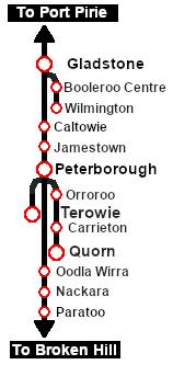
<td align="center" width=200>[[image:SAR Nth Division Strip Map.png|link=|alt=SAR Northern Division Map]]</td> | <td align="center" width=200>[[image:SAR Nth Division Strip Map.png|link=|alt=SAR Northern Division Map]]</td> | ||
</tr> | </tr> | ||
</table | </table> | ||
Latest revision as of 08:56, 22 November 2022
| SAR Peterborough Narrow Gauge Division | ||
| Track Diagrams and Location Data | ||
 All links will open in this window |
  |
|
 |
||||||||||||||||||||||||||||||||||||||||||||||||||||||||||||||||||||||||||||||||||||||||||






