SAR Belalie North (Basic): Difference between revisions
From TrainzOnline
Jump to navigationJump to search
mNo edit summary |
mNo edit summary |
||
| Line 1: | Line 1: | ||
<table> | |||
<tr valign="top"> | |||
<td width=750> | |||
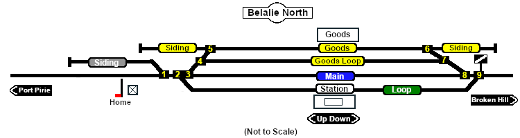
[[Image:SAR_Belalie_North_Basic.png|link=|alt=Balalie North]]<br> | [[Image:SAR_Belalie_North_Basic.png|link=|alt=Balalie North]]<br> | ||
Main Line with Passing, Station and Goods Loops. Unmanned station on the '''Gladstone to Peterborough''' section of the '''Port Pirie to Broken Hill line'''. | Main Line with Passing, Station and Goods Loops. Unmanned station on the '''Gladstone to Peterborough''' section of the '''Port Pirie to Broken Hill line'''. | ||
<table bgcolor="lightgrey" bordercolor="lightgrey"> | <table bgcolor="lightgrey" bordercolor="lightgrey"> | ||
<tr valign="middle"> | <tr valign="middle"> | ||
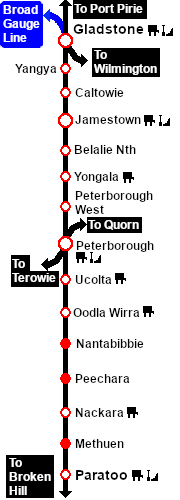
<td width=220 align="right">[[Image:SAR_PortPirie-BrokenHill_Line.png|link=alt=PortPirie-BrokenHill Line]]</td> | <td width=220 align="right">[[Image:SAR_PortPirie-BrokenHill_Line.png|link=|alt=PortPirie-BrokenHill Line]]</td> | ||
<td width=110 align="center">[[Image:Next Left.png|link=|alt=]]<br>[[Image:SAR_Jamestown_Name.png|link=SAR Jamestown (Basic)|alt=Jamestown|Next Up Location]]</td> | <td width=110 align="center">[[Image:Next Left.png|link=|alt=]]<br>[[Image:SAR_Jamestown_Name.png|link=SAR Jamestown (Basic)|alt=Jamestown|Next Up Location]]</td> | ||
<td width=90 align="center">[[Image:Location Index.png|link=SAR Index (Basic)|alt=Location Index|Location Index]]</td> | <td width=90 align="center">[[Image:Location Index.png|link=SAR Index (Basic)|alt=Location Index|Location Index]]</td> | ||
<td width=110 align="center">[[Image:Next Right.png|link=|alt=]]<br>[[Image:SAR_Yongala_Name.png|link=SAR Yongala (Basic)|alt=Yongala|Next Down Location]]</td> | <td width=110 align="center">[[Image:Next Right.png|link=|alt=]]<br>[[Image:SAR_Yongala_Name.png|link=SAR Yongala (Basic)|alt=Yongala|Next Down Location]]</td> | ||
<td width=220 align="left">[[Image:SAR_PortPirie-BrokenHill_Line.png|link=alt=PortPirie-BrokenHill Line]]</td> | <td width=220 align="left">[[Image:SAR_PortPirie-BrokenHill_Line.png|link=|alt=PortPirie-BrokenHill Line]]</td> | ||
</tr> | </tr> | ||
<tr valign="top"> | <tr valign="top"> | ||
Revision as of 22:50, 12 August 2019
|
Main Line with Passing, Station and Goods Loops. Unmanned station on the Gladstone to Peterborough section of the Port Pirie to Broken Hill line.
|
 |
||||||||||||||||||||||||||||||||||||||||||||||||||||||||||