SAR Belalie North: Difference between revisions

From TrainzOnline
Jump to navigationJump to search
Pware (talk | contribs)
mNo edit summary
Pware (talk | contribs)
added internal links
Line 2: Line 2:
<tr valign="top">
<tr valign="top">
<td width=750>
<td width=750>
<span style="font-weight: 700; font-size: 18px; background-color: blue; color: white;">&nbsp;Track Diagram & Data&nbsp;</span><br>
 
<table width=700> <!-- BEGIN Track Title Link -->
<tr valign="top">
<td width=600>{{Anchor|TrackData}}<span style="font-weight: 700; font-size: 18px; background-color: blue; color: white;">&nbsp;Track Diagram & Data&nbsp;</span></td>
<td align=right width=100>[[image:ToPaths.png|link=#PathData]]</td>
</tr>
</table> <!-- END Track Title Link -->
 
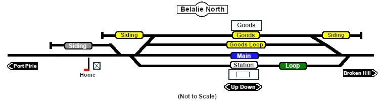
[[Image:SAR_Belalie_North_Basic.png|link=|alt=Belalie North]]<br>
[[Image:SAR_Belalie_North_Basic.png|link=|alt=Belalie North]]<br>


<table> <!-- BEGIN Track Diagram Table -->
<tr valign="top">
<tr valign="top">
<!-- <td width=600> -->
<td width=750>
<td width=750>
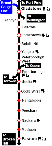
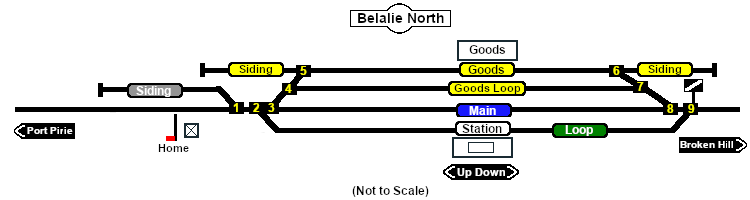
Station, goods and passing loops with sidings. Unmanned station on the <span style="font-weight: 700; color: white; background-color: black;">&nbsp;Port Pirie-Broken Hill Line&nbsp;</span>. This location was bypassed when the line was converted to standard gauge in 1969.
</td>
</td>
<!-- <td width=150>
[[image:SwitchToPaths.png|link=SAR Jamestown|alt=To Paths|Show Path Diagram]]
</td> -->
</tr>
</tr>
</table> <!-- END Track Diagram Table -->
Line 211: Line 214:
<tr valign="top">
<tr valign="top">
<td width=750>
<td width=750>
<span style="font-weight: 700; font-size: 18px; background-color: blue; color: white;">&nbsp;Path Diagram & Data&nbsp;</span><br>
 
<table width=700> <!-- BEGIN Path Title Link -->
<tr valign="top">
<td width=600>{{Anchor|PathData}}<span style="font-weight: 700; font-size: 18px; background-color: blue; color: white;">&nbsp;Path Diagram & Data&nbsp;</span></td>
<td align=right width=100>[[image:ToTracks.png|link=#TrackData]]</td>
</tr>
</table> <!-- END Path Title Link -->
 
[[Image:SAR_Belalie_North.png|link=|alt=Belalie North]]<br>
[[Image:SAR_Belalie_North.png|link=|alt=Belalie North]]<br>
</td>
</td>

Revision as of 21:19, 5 November 2020

 Track Diagram & Data 

Belalie North

Station, goods and passing loops with sidings. Unmanned station on the  Port Pirie-Broken Hill Line . This location was bypassed when the line was converted to standard gauge in 1969.

PortPirie-BrokenHill
Jamestown
Location Index
Yongala
PortPirie-BrokenHill
Commodities: (load and/or unload)
Passengers
Passengers
Goods
Goods
Facilities:
Loop
Loop
 Track Markers 
Destinations for "Drive To Trackmark ..." commands
 Approach from Port Pirie   Error creating thumbnail: /bin/bash: line 1: /usr/bin/convert: No such file or directory Error code: 127 Belalie Nth Main Approach Dn
 Approach from Broken Hill   Error creating thumbnail: /bin/bash: line 1: /usr/bin/convert: No such file or directory Error code: 127 Belalie Nth Main Approach Up
Station  Error creating thumbnail: /bin/bash: line 1: /usr/bin/convert: No such file or directory Error code: 127 Belalie Nth Station Up Error creating thumbnail: /bin/bash: line 1: /usr/bin/convert: No such file or directory Error code: 127 Belalie Nth Station Dn
Main  Error creating thumbnail: /bin/bash: line 1: /usr/bin/convert: No such file or directory Error code: 127 Belalie Nth Main Up Error creating thumbnail: /bin/bash: line 1: /usr/bin/convert: No such file or directory Error code: 127 Belalie Nth Main Dn
Loop  Error creating thumbnail: /bin/bash: line 1: /usr/bin/convert: No such file or directory Error code: 127 Belalie Nth Loop Up Error creating thumbnail: /bin/bash: line 1: /usr/bin/convert: No such file or directory Error code: 127 Belalie Nth Loop Dn
  Switches  
No. Name Facing and L/R Directions
(default direction first)
No. Name Facing and L/R Directions
(default direction first)
BN 1 Up (L) Port Pirie, (R) Siding 1 BN 2 Down (L) Main, (R) Station
BN 3 Down (R) Main, (L) Loop/Goods Shed BN 4 Down (R) Loop, (L) Goods Shed
BN 5 Up (L) Port Pirie, (R) Siding 2 BN 6 Down (L) Siding 3, (R) Broken Hill
BN 7 Up (L) Loop, (R) Goods Shed BN 8 Up (R) Main, (L) Station
BN 9 Up (L) Main, (R) Loop/Goods Shed  
 Switch Sets 
 Port Pirie -  Station   1 -L  2 -R  Broken Hill -  Station   9 -L  8 -L
 Port Pirie -  Main   1 -L  2 -L  3 -R  Broken Hill -  Main   9 -L  8 -R
 Port Pirie -  Loop   1 -L  2 -L  3 -L  4 -R  Broken Hill -  Loop   9 -R  7 -L
 Port Pirie -  Goods   1 -L  2 -L  3 -L  4 -L  5 -L  Broken Hill -  Goods   9 -R  7 -R  6 -R
 Path Diagram & Data 

Belalie North

 From  To EIT Paths Descriptions
          Port Pirie to Broken Hill Through (non stopping) service from Gladstone or Jamestown to Peterborough
   Port Pirie to Station to Broken Hill Through service from Gladstone or Jamestown to Peterborough stopping at station
          Port Pirie to Loop Arriving service from Gladstone or Jamestown to loop
          Port Pirie to Goods Arriving service from Gladstone or Jamestown to goods
          Loop to Broken Hill Departing service to Peterborough from loop
          Goods to Broken Hill Departing service to Peterborough from goods
All reverse paths (e.g. to ) are also available
Gladstone-Paratoo Strip Map