SAR Jamestown Paths: Difference between revisions
From TrainzOnline
Jump to navigationJump to search
Created page with "<table> <!-- BEGIN TOP TABLE --> <tr valign="top"> <td width=750> <table width=750> <!-- BEGIN TABBED link list with Paths page active--> <tr valign="top"> <td colspan=3 al..." |
mNo edit summary |
||
| Line 5: | Line 5: | ||
<table width=750> <!-- BEGIN TABBED link list with Paths page active--> | <table width=750> <!-- BEGIN TABBED link list with Paths page active--> | ||
<tr valign="top"> | <tr valign="top"> | ||
<td | <td align="center">[[Image:line740.png|link=]]</td> | ||
</tr> | </tr> | ||
<tr valign="top"> | <tr valign="top"> | ||
<td align="center">[[image:Tab_HM_Grey.png|link=SAR_Jamestown]] [[image:Tab_IN_Grey.png|link=SAR_Jamestown_Industry]] [[image:Tab_TM_Grey.png|link=SAR_Jamestown_TrackMarks]] [[image:Tab_PH_White.png|link=]] [[image:Tab_SW_Grey.png|link=SAR_Jamestown_Switches]]</td> | |||
<td align=" | </tr> | ||
<tr valign="top"> | <tr valign="top"> | ||
<td | <td align="center">[[Image:line740.png|link=]]</td> | ||
</tr> | </tr> | ||
</table> <!-- END TABBED link list --> | </table> <!-- END TABBED link list --> | ||
<table bgcolor="lightgrey" bordercolor="lightgrey" width=750> <!-- BEGIN Location link table with LINE and STATION NAMES --> | |||
<tr valign="middle"> | |||
<td width=220 align="right">[[Image:SAR_PortPirie-BrokenHill_Line.png|link=SAR_Port_Pirie-Broken_Hill|alt=PortPirie-BrokenHill|Show Port Pirie-Broken Hill]]</td> | |||
<td width=110 align="center">[[Image:Next Left.png|link=|alt=]]<br>[[Image:SAR_Caltowie_Name.png|link=SAR Caltowie|alt=Caltowie|Next Up Location]]</td> | |||
<td width=90 align="center">[[Image:Location Index.png|link=SAR Index|alt=Location Index|Location Index]]</td> | |||
<td width=110 align="center">[[Image:Next Right.png|link=|alt=]]<br>[[Image:SAR_Belalie_North_Name.png|link=SAR Belalie North|alt=Belalie North|Next Down Location]]</td> | |||
<td width=220 align="left">[[Image:SAR_PortPirie-BrokenHill_Line.png|link=SAR_Port_Pirie-Broken_Hill|alt=PortPirie-BrokenHill|Show Port Pirie-Broken Hill]]</td> | |||
</tr> | |||
</table> <!-- BEGIN Location link table with LINE and STATION NAMES --> | |||
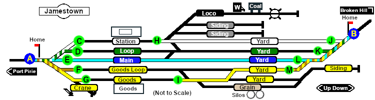
[[image:SAR_Jamestown_Paths.png|link=|alt=Jamestown Paths map]] | [[image:SAR_Jamestown_Paths.png|link=|alt=Jamestown Paths map]] | ||
Revision as of 06:52, 24 November 2020
|
 |
||||||||||||||||||||||||||||||||||||||||||||||||||||||||||||