SAR Belalie North: Difference between revisions
From TrainzOnline
Jump to navigationJump to search
mNo edit summary |
mNo edit summary |
||
| Line 1: | Line 1: | ||
<!-- | <!-- V1.0 and V2.0 versions --> | ||
< | <!-- V2.0 Stockyard added to map, industries and trackmarks --> | ||
<!-- BEGIN V1.0 --> | |||
<table> | |||
<tr valign="top"> | <tr valign="top"> | ||
<td width=750> | <td width=750> | ||
<table width=750 | <table width=750> | ||
<tr valign="top"> | <tr valign="top"> | ||
<td align="center">[[Image:line740.png|link=]]</td> | <td align="center">[[Image:line740.png|link=]]</td> | ||
| Line 14: | Line 16: | ||
<td align="center">[[Image:line740.png|link=]]</td> | <td align="center">[[Image:line740.png|link=]]</td> | ||
</tr> | </tr> | ||
</table | </table> | ||
<table bgcolor="lightgrey" bordercolor="lightgrey" width=750 | <table bgcolor="lightgrey" bordercolor="lightgrey" width=750> | ||
<tr valign="middle"> | <tr valign="middle"> | ||
| Line 26: | Line 28: | ||
</tr> | </tr> | ||
</table | </table> | ||
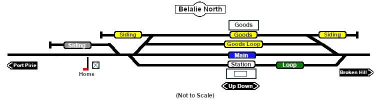
[[image:SAR_Belalie North.png|link=|alt=Belalie North map]] | [[image:SAR_Belalie North.png|link=|alt=Belalie North map]] | ||
<table bgcolor="lightgrey" bordercolor="lightgrey" width=750 | <table bgcolor="lightgrey" bordercolor="lightgrey" width=750> | ||
<tr valign="top"> | <tr valign="top"> | ||
<td><span style="font-weight: 700; background-color: black; color: white;"> Commodities: </span> | <td><span style="font-weight: 700; background-color: black; color: white;"> Commodities: </span> | ||
<table width=300 | <table width=300> | ||
<tr valign="top"> | <tr valign="top"> | ||
| Line 45: | Line 47: | ||
</tr> | </tr> | ||
</table | </table> | ||
</td> | </td> | ||
<td> | <td> | ||
<table width=175 | <table width=175> | ||
<tr valign="top"> | <tr valign="top"> | ||
<td width=175> </td | <td width=175> </td> | ||
</tr> | </tr> | ||
</table | </table> | ||
</td> | </td> | ||
<td><span style="font-weight: 700;"><span style="background-color: black; color: white;"> Facilities: </span></span> | <td><span style="font-weight: 700;"><span style="background-color: black; color: white;"> Facilities: </span></span> | ||
<table width=250 | <table width=250> | ||
<tr valign="top"> | <tr valign="top"> | ||
<td align="center" width=50>[[Image:Loop_Icon.png|link=|alt=Loop]]<br><span style="font-size: 10px; font-weight: 700;">Loop</span><br>[[image:Loop_Label.png|link=]]</td> | <td align="center" width=50>[[Image:Loop_Icon.png|link=|alt=Loop]]<br><span style="font-size: 10px; font-weight: 700;">Loop</span><br>[[image:Loop_Label.png|link=]]</td> | ||
<td align="center" width=50> </td> | <td align="center" width=50> </td> | ||
<td align="center" width= | <td align="center" width=50> </td> | ||
<td align="center" width=50> </td> | <td align="center" width=50> </td> | ||
</tr> | |||
</table> | |||
</td> | |||
</tr> | |||
</table> | |||
<table> | |||
<tr valign="top"> | |||
<td width=750> | |||
Unmanned station on the <span style="font-weight: 700; color: white; background-color: black;"> Port Pirie-Broken Hill Line </span>. At 621m (2,037ft) '''Belalie North''' was the highest point in the entire '''SAR''' system.<br> | |||
Station, goods and passing loops with sidings.<br> | |||
This location was bypassed in favour of an alignment with easier grades when the line was converted to standard gauge during 1969-1970. | |||
</td> | |||
</tr> | |||
<tr valign="top"> | |||
<td align="center">[[Image:line740.png|link=]]</td> | |||
</tr> | |||
</table> | |||
</td> | |||
<td> | |||
[[Image:SAR_PortPirie-BrokenHill_Line.png|link=SAR_Port_Pirie-Broken_Hill|alt=PortPirie-BrokenHill|Show Port Pirie-Broken Hill]]<br> | |||
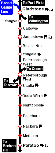
[[Image:SAR_Gladstone-Paratoo Strip Map.png|link=|alt=Gladstone-Paratoo Strip Map]]</td> | |||
</tr> | |||
</table> | |||
<!-- END V1.0 --> | |||
<!-- BEGIN V2.0 | |||
<table> | |||
<tr valign="top"> | |||
<td width=750> | |||
<table width=750> | |||
<tr valign="top"> | |||
<td align="center">[[Image:line740.png|link=]]</td> | |||
</tr> | |||
<tr valign="top"> | |||
<td align="center">[[image:Tab_HM_White.png|link=]] [[image:Tab_IN_Grey.png|link=SAR_Belalie North_Industry]] [[image:Tab_TM_Grey.png|link=SAR_Belalie North_TrackMarks]] [[image:Tab_SW_Grey.png|link=SAR_Belalie North_Switches]] [[image:Tab_Blank_Grey.png|link=]]</td> | |||
</tr> | |||
<tr valign="top"> | |||
<td align="center">[[Image:line740.png|link=]]</td> | |||
</tr> | |||
</table> | |||
<table bgcolor="lightgrey" bordercolor="lightgrey" width=750> | |||
<tr valign="middle"> | |||
<td width=220 align="right">[[Image:SAR_PortPirie-BrokenHill_Line.png|link=SAR_Port_Pirie-Broken_Hill|alt=PortPirie-BrokenHill|Show Port Pirie-Broken Hill]]</td> | |||
<td width=110 align="center">[[Image:Next Left.png|link=|alt=]]<br>[[Image:SAR_Jamestown_Name.png|link=SAR Jamestown|alt=Jamestown|Next Up Location]]</td> | |||
<td width=90 align="center">[[Image:Location Index.png|link=SAR Index|alt=Location Index|Location Index]]<br>[[image:Scenario Index.png|link=SAR Peterborough Base Session|alt=Scenarios|Scenario Index]]</td> | |||
<td width=110 align="center">[[Image:Next Right.png|link=|alt=]]<br>[[Image:SAR_Yongala_Name.png|link=SAR Yongala|alt=Yongala|Next Down Location]]</td> | |||
<td width=220 align="left">[[Image:SAR_PortPirie-BrokenHill_Line.png|link=SAR_Port_Pirie-Broken_Hill|alt=PortPirie-BrokenHill|Show Port Pirie-Broken Hill]]</td> | |||
</tr> | |||
</table> | |||
<table width=750> | |||
<tr valign="top"> | |||
<td>[[image:SAR_Belalie North.png|link=|alt=Belalie North map]]</td> | |||
<tr valign="top"> | |||
<td align="center"><span style="font-weight: 700;">Map and commodities updated in <span style="color: blue;">SAR Peterborough Narrow Gauge Division v2.0</span></span><br> | |||
[[Image:line740.png|link=]]</td> | |||
</tr> | |||
</table> | |||
<table bgcolor="lightgrey" bordercolor="lightgrey" width=750> | |||
<tr valign="top"> | |||
<td><span style="font-weight: 700; background-color: black; color: white;"> Commodities: </span> | |||
<table width=300> | |||
<tr valign="top"> | |||
<td align="center" width=50>[[Image:Passenger_Icon_off.png|link=|alt=Passengers]]<br><span style="font-size: 10px; font-weight: 700;">Passengers</span><br>[[image:Station_Label.png|link=]]</td> | |||
<td align="center" width=50>[[Image:Goods_Icon.png|link=|alt=Goods]]<br><span style="font-size: 10px; font-weight: 700;">Goods</span><br>[[image:Goods_Label.png|link=]]</td> | |||
<td align="center" width=50>[[Image:Livestock_Icon.png|link=|alt=Livestock]]<br><span style="font-size: 10px; font-weight: 700;">Livestock</span><br>[[image:Stockyard_Label.png|link=]]</td> | |||
<td align="center" width=50> </td> | |||
<td align="center" width=50> </td> | |||
</tr> | |||
</table> | |||
</td> | |||
<td> | |||
<table width=175> | |||
<tr valign="top"> | |||
<td width=175> </td> | |||
</tr> | |||
</table> | |||
</td> | |||
<td><span style="font-weight: 700;"><span style="background-color: black; color: white;"> Facilities: </span></span> | |||
<table width=250> | |||
<tr valign="top"> | |||
<td align="center" width=50>[[Image:Loop_Icon.png|link=|alt=Loop]]<br><span style="font-size: 10px; font-weight: 700;">Loop</span><br>[[image:Loop_Label.png|link=]]</td> | |||
<td align="center" width=50> </td> | |||
<td align="center" width=50> </td> | |||
<td align="center" width=50> </td> | |||
</tr> | </tr> | ||
</table | </table> | ||
</td> | </td> | ||
</tr> | </tr> | ||
</table | </table> | ||
<table | <table> | ||
<tr valign="top"> | <tr valign="top"> | ||
<td width=750> | <td width=750> | ||
Unmanned station on the <span style="font-weight: 700; color: white; background-color: black;"> Port Pirie-Broken Hill Line </span>.<br> | Unmanned station on the <span style="font-weight: 700; color: white; background-color: black;"> Port Pirie-Broken Hill Line </span>. At 621m (2,037ft) '''Belalie North''' was the highest point in the entire '''SAR''' system.<br> | ||
Station, goods and passing loops with sidings | Station, goods and passing loops with a stockyard and storage sidings.<br> | ||
This location was bypassed in favour of an alignment with easier grades when the line was converted to standard gauge during 1969-1970. | This location was bypassed in favour of an alignment with easier grades when the line was converted to standard gauge during 1969-1970. | ||
| Line 91: | Line 199: | ||
</tr> | </tr> | ||
</table | </table> | ||
</td> | </td> | ||
| Line 98: | Line 206: | ||
[[Image:SAR_Gladstone-Paratoo Strip Map.png|link=|alt=Gladstone-Paratoo Strip Map]]</td> | [[Image:SAR_Gladstone-Paratoo Strip Map.png|link=|alt=Gladstone-Paratoo Strip Map]]</td> | ||
</tr> | </tr> | ||
</table> | </table> | ||
END V2.0 --> | |||
Revision as of 07:12, 26 July 2022
|
 |