SAR Booleroo Centre: Difference between revisions
mNo edit summary |
No edit summary |
||
| Line 1: | Line 1: | ||
<!-- V1.0 --> | <!-- V2.0 (seperate V1.0 file) --> | ||
<table> | <table> | ||
<tr valign="top"> | <tr valign="top"> | ||
| Line 30: | Line 30: | ||
<tr valign="top"> | <tr valign="top"> | ||
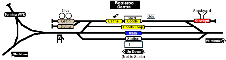
<td>[[image:SAR_Booleroo_Centre.png|link=|alt=Booleroo_Centre map]]</td> | <td>[[image:SAR_Booleroo_Centre.png|link=|alt=Booleroo_Centre map]]</td> | ||
</tr> | |||
<tr valign="top"> | |||
<td align="center"><span style="font-weight: 700;">Updated for <span style="color: blue;">SAR Peterborough Narrow Gauge Division v2.0</span>. For the original <span style="color: blue;">V1.0 version</span> click <span style="background-color: yellow;">[[SAR_Booleroo_Center_V1|here]]</span><br> | |||
[[Image:line740.png|link=]]</td> | |||
</tr> | </tr> | ||
</table> | </table> | ||
| Line 43: | Line 47: | ||
<td align="center" width=50>[[Image:Passenger_Icon_off.png|link=|alt=Passengers]]<br><span style="font-size: 10px; font-weight: 700;">Passengers</span><br>[[image:Station_Label.png|link=]]</td> | <td align="center" width=50>[[Image:Passenger_Icon_off.png|link=|alt=Passengers]]<br><span style="font-size: 10px; font-weight: 700;">Passengers</span><br>[[image:Station_Label.png|link=]]</td> | ||
<td align="center" width=50>[[Image:Goods_Icon.png|link=|alt=Goods]]<br><span style="font-size: 10px; font-weight: 700;">Goods</span><br>[[image:Goods_Label.png|link=]]</td> | <td align="center" width=50>[[Image:Goods_Icon.png|link=|alt=Goods]]<br><span style="font-size: 10px; font-weight: 700;">Goods</span><br>[[image:Goods_Label.png|link=]]</td> | ||
<td align="center" width=50>[[Image:Grain_Icon.png|link=|alt=Grain]]<br><span style="font-size: 10px; font-weight: 700;">Grain</span><br>[[image:Grain_Label.png|link=]]< | <td align="center" width=50>[[Image:Grain_Icon.png|link=|alt=Grain]]<br><span style="font-size: 10px; font-weight: 700;">Grain</span><br>[[image:Grain_Label.png|link=]]<br>[[image:WYE_Label.png|link=]]<br> | ||
<td align="center" width=50>[[Image:Livestock_Icon.png|link=|alt=Livestock]]<br><span style="font-size: 10px; font-weight: 700;">Livestock</span><br>[[image:Stockyard_Label.png|link=]]</td> | <td align="center" width=50>[[Image:Livestock_Icon.png|link=|alt=Livestock]]<br><span style="font-size: 10px; font-weight: 700;">Livestock</span><br>[[image:Stockyard_Label.png|link=]]</td> | ||
<td align="center" width=50> </td> | <td align="center" width=50> </td> | ||
| Line 56: | Line 60: | ||
<tr valign="top"> | <tr valign="top"> | ||
<td align="center" width=50>[[Image:Water_Icon.png|link=|alt=Water]]<br><span style="font-size: 10px; color: white; font-weight: 700;">Water</span><br>[[image: | <td align="center" width=50>[[Image:Water_Icon.png|link=|alt=Water]]<br><span style="font-size: 10px; color: white; font-weight: 700;">Water</span><br>[[image:Grain_Label.png|link=]]<td> | ||
<td align="center" width=50> </td> | <td align="center" width=50> </td> | ||
<td align="center" width=50> </td> | <td align="center" width=50> </td> | ||
| Line 88: | Line 92: | ||
A manned station on the <span style="font-weight: 700; color: white; background-color: black;"> Gladstone-Wilmington Line </span> until 1983 when all the station staff on the line were withdrawn.<br> | A manned station on the <span style="font-weight: 700; color: white; background-color: black;"> Gladstone-Wilmington Line </span> until 1983 when all the station staff on the line were withdrawn.<br> | ||
A station and goods loop | A station and goods loop. Two grain loading facilities, storage sheds for bagged grain and grain sidings. A stockyard siding. Loco watering facilities and a turning WYE. An engine shed was present on the '''WYE''' until 1915.<br> | ||
The '''Gladstone-Wilmington Line''' is '''unsignalled'''. Train Order working is in operation on the line.<br> | The '''Gladstone-Wilmington Line''' is '''unsignalled'''. Train Order working is in operation on the line.<br> | ||
| Line 109: | Line 113: | ||
<td> | <td> | ||
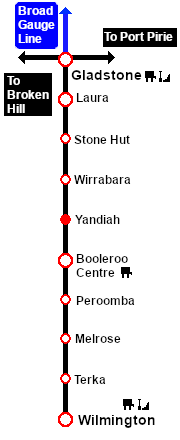
[[Image:SAR_Gladstone-Wilmington_Line.png|link=SAR_Gladstone_Wilmington|alt=Gladstone-Wilmington|Show Gladstone-Wilmington]]<br> | [[Image:SAR_Gladstone-Wilmington_Line.png|link=SAR_Gladstone_Wilmington|alt=Gladstone-Wilmington|Show Gladstone-Wilmington]]<br> | ||
[[Image:SAR_Gladstone-Wilmington Strip Map.png|link=|alt=Gladstone-Wilmington Strip Map]] | [[Image:SAR_Gladstone-Wilmington Strip Map V2.png|link=|alt=Gladstone-Wilmington Strip Map]] | ||
</td> | </td> | ||
</tr> | </tr> | ||
</table> | </table> | ||
Revision as of 11:01, 14 November 2022
|
|